
The government’s designation of public streets and government buildings in central Colombo as High Security Zones (HSZs) by invoking the Official Secrets Act has led to widespread condemnation at home and abroad with several fundamental rights petitions already filed or being filed against the order.
The areas are the Parliament (Schedule A) , the Supreme Court, High Court, Magistrate Court, Attorney General’s Department (Schedule B), Presidential Secretariat, President’s House, Police, Navy, and Army headquarters Schedule (Schedule C), the Ministry of Defence (Schedule D), Air Force Headquaters (Schedule E) Prime Minister’s Office (Schedule F), Temple Trees (Schedule G) and the official residences of the Secretary to the Ministry of Defence and the Commanders of Tri Forces (Schedule H).
Under the regulation, police can arrest anyone inside these zones and only the High Court can grant bail to those detained. “These broad, severe restrictions threaten the excessive use of force and prolonged detention for people exercising their rights to peaceful assembly and expression,” Human Rights Watch said. “The sweeping new regulation severely restricting public protest in Colombo is President Ranil Wickremesinghe’s latest desperate attempt to stop people from protesting.”
The Centre of Policy Alternatives (CPA) charged that the declaration of HSZs was the government’s latest attempt to stifle dissent and prevent people from exercising their fundamental right to protest. “This clear abuse of the Official Secrets Act is the latest in a series of attempts by the United National Party [UNP] – Sri Lanka Podujana Party [SLPP] government to arbitrarily restrict fundamental rights guaranteed under the Constitution, stifle dissent and create a climate of fear within the country. The orders/ regulations are also another example of the use of public security laws by the UNP- SLPP government to clamp down on all form of dissent,” CPA said in a statement.
The Human Rights Commission said the HSZs violated the fundamental rights of the people and reiterated that the Official Secret Act could not be adopted to declare HSZs. It advised the government to withdraw the gazette. In a now familiar Rajapaksa-like reversal, President Wickremesinghe is reported to have asked the Attorney General to cancel the gazette notification because economic advisors told him that they were bad for businesses.
In an attempt to better understand what these zones look like in actuality, Groundviews has prepared a series of visuals and guides on Google Maps and Google Earth to demonstrate the limits and boundaries of each zone using what is described in the gazette. The article also seeks to expand on and demonstrate some of the difficulty in mapping out such areas on the basis of interpreting what the gazette says whilst aligning with the serious concerns and questions of practicality and purpose in demarcating such HSZs during peacetime under the Official Secrets Act.
The Maps
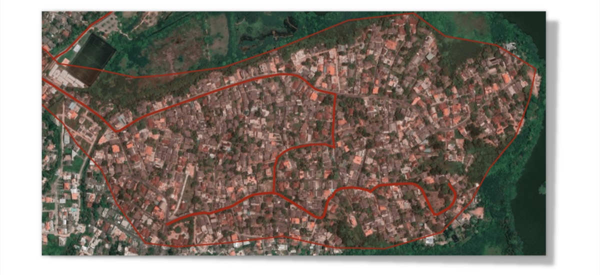
Schedule – (A)
Parliament Complex – Click here to enlarge
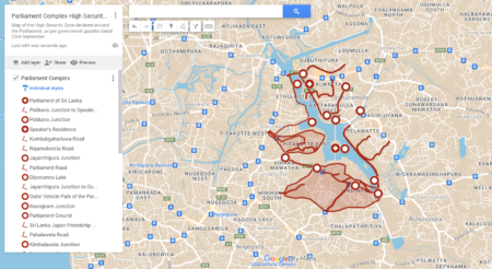
Schedule – (B)
Supreme Court Complex, High Court Complex- Colombo, Magistrate Court Complex- Colombo and Attorney General’s Department –
Click here to enlarge.
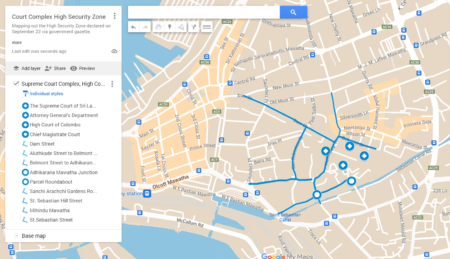
Schedule – (C)
Presidential Secretariat, President’s House, Sri Lanka Navy Headquarters and Police Headquarters – Click here to enlarge
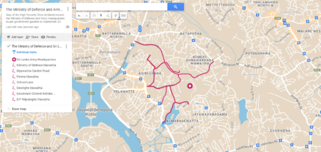
Schedule – (D)
The Ministry of Defence and Sri Lanka Army Headquarters- Akuregoda – Click here to enlarge
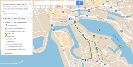
Schedule – (E)
Sri Lanka Air Force Headquarters- (Slave Island) – Click here to enlarge
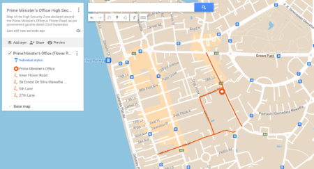
Schedule (F)
Prime Minister’s Office (Flower Road) – Click here to enlarge
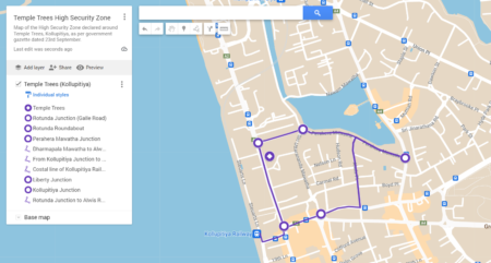
Schedule (G)
Temple Trees (Kollupitiya) – Click here to enlarge
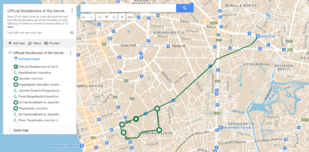
Schedule – (H)
Official Residencies of the Secretary to the Ministry of Defence and the Commanders of Tri Forces – Click here to enlarge
One of the main issues in mapping the areas demarcated under the HSZs are the discrepancies in how some of these areas are described under the gazette. Some specify roads and junctions, while others demarcate a specific path or roadway connecting two or more points within a zone. These are direct and easy enough to understand and map out. However, at times the gazette specifies an ‘area’ within a marked schedule with no distinct clarification on what the limits of this area may be. This is in addition to the gazette order which states ‘The High Security Zones, which comprise of the areas specified in the Schedule of these Orders’.
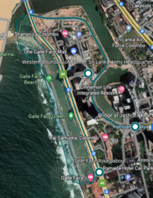
Elsewhere like in the instance of security zone under Schedule H, the gazette makes a note of the ‘the respective seashore between Galle Face roundabout and Chaithya Road junction’ seemingly implying without implicitly stating that the entirety of Galle Face Green would be brought under a HSZ.
Issues like these combined with the discrepancies within the Sinhala and the English gazette blur and leave room for interpretation and speculation as to what the HSZs would actually cover. With no official map to accompany the gazette, nor even a set of guidelines to clarify the limits of a demarcated zone, mapping the area out on the basis of what the gazette provides to determine what portions of a neighborhood, (and yes, most of these areas are neighborhoods) come under an HSZ and what doesn’t is frustrating work. Nevertheless, it is still vital to understand these zones beyond an area limited to the gazette and extend it to what this means geographically using what little information is provided. This is especially important to highlight due to the implications such a zone may have on those that reside or work within them. For a quick Q&A on this see this guide prepared by the Centre for Policy Alternatives.
Extended Roads and Areas within HSZs
Where the gazette classifies ‘areas’ brought under an HSZ like those within the Parliament zone, a vague description of places within the locality follow. This is especially worthwhile noting as such ‘areas’ are marked within some of the most highly residential neighborhoods, and would thus have serious implications on those within the zone. One especially wonders how orders such as ‘No vehicle should be parked within the High Security Zones unless reserved for parking by the competent authority’ will be enforced in such neighborhoods.
Within the south border of the Parliament HSZ, for example, the gazette specifies a large swathe of land perhaps on account of the Parliament Members housing complex in Madiwela. Gazetted as “the area up to Pin Niyara including Sudarshana Mawatha, Daham Mawatha, Gamage Mawatha, Eeyam Poruwa Temple Road, Byroads and MP’s Quarters – Madiwela, Pita Wella Road at the back of MP’s Quarters including Diyawanna Lake.”
Here, while naming the specific roads that are brought under the HSZ, including the Thalawathugoda road that connects the Western and Southern zones of the Parliament HSZ, it also declares ‘an area’ around the same. Furthermore, the mention of Pita Wella Road elicits further confusion as the road is nowhere close to the MP’s Quarters, where the gazette seems to imply the road as being behind or adjacent to the MPs housing scheme. Pita Wella Road, as a matter of fact is a by road that connects Mirihana to the Pragathipura/Madiwela area; some 2km away. This is curious as the Madiwela Road, the main road that leads behind is not brought under the HSZ. Thereby defying the logic of creating a zone around the MP’s Quarters. The only assumption to be made here by the inclusion of ‘Pita Wella Road at the back of MP’s Quarters’ is that that the ‘area upto Pinniyara Junction’ the gazette specifies extends as far South as Pita Wella Road, bringing a large area of land in Madiwela under the HSZ.
Further to the West, the gazette makes mention of the Beddagana Road, and then without any intent to clarify, also mentions ‘Beddagana’. The only takeaway from this could be the entirety of the highly residential Beddagana area being brought under the Parliament HSZ. To add to further confusion, the gazette specifies Polduwa road and then Polduwa junction which was already named in the Northern zone. Although the Sinhala gazette provides some clarification to mean that the two zones are meant to connect at Polduwa junction, the specific mention of Polduwa junction and especially Polduwa road (in both Sinhala and English gazettes) as being part of the western zone when it is geographically situated to the North is confusing to say the least. It is further made worse by the gazette describing the manner in which the Western and Northern zones are meant to close off the Parliament complex HSZ in at least three different ways; all semingly along the same route.
Elsewhere, the inability of the gazette to specify which section of a road comes under the security zone, allows it leeway to once again have large sections brought under a security zone due to the gazette’s lack of clarity and its consistent manner of description. The best example of this is at the Security Zone declared around the Official Residences of the Secretary to the Ministry of Defence and the Commanders of Tri Forces. The Northern zone for example states Bauddaloka Mawatha; with no clarity as to how much of Bauddaloka Mawatha would fit into the zone. Thus implying a security zone around the road extending the entire 3 km stretch from the Cotta road junction to Thunmulla junction. This is in contrast to how the zone has a very specific trajectory to the South, where it begins at the Jawatta junction and continues only a further 400 km or so to be cut off at Keppettipola junction without extending the zone to the entirety of Jawatta Road upto Thimbirigasyaya. This zone also without much distinction between the two marks its Southern and Western borders with the same locations; easy enough to understand when mapped out, not so when trying to understand what it means.
Although likely to be rescinded, what’s expanded on above are just some of the issues encountered in the process of mapping out the 8 areas gazetted as High Security Zones on the 23rd of September. It speaks to just a single component of a flawed, ill thought out and authoritative strategy by the government to stifle dissent. The lack of clarity in the gazette, the discrepancies in its geography, its language, and indeed the overall lack of concern for the tensions it has the ability to create within the populous through the mapping of these areas is telling of a last ditch effort by a government desperate to keep a tight lid on mounting dissent and disapproval.